Monday, January 20, 2014

Oops! I Missed The Bend In The Road - Twice!

We've been hearing a lot about record breaking weather recently. The mainstream media is full of stories about the "Ridiculously Resilient Ridge" off the west coast being responsible for not only the lowest annual rainfall totals ever recorded in California, but also the new high temperature records that are being set almost daily recently. Then there was the dreaded "Polar Vortex" last month that was responsible for the lowest temperatures that the eastern United States had seen in fifty years (beware, it might return this week!). And even in the Williams Today Forum we are reading about such things as "Backside Slider Lows" producing record breaking east to west winds. All this talk about the weather reminds me of that famous quote:

"Everybody talks about the weather, but nobody does anything about it." - Mark Twain

Well, that's not true with glider pilots. They talk about it, and then they try to exploit it! For whatever reason, we seem to have been experiencing an increase in the number and frequency of fantastic wave days at Williams in the past few months.

The most recent fantastic wave day coincided with the Valley Soaring Association's Annual Holiday Dinner and first Winter Seminar on January 11, 2014. A few weeks before the big event, Peter Kelly and Kempton Izuno started discussing the weather for the day here on the Williams Today Forum. And as the day got closer and closer, it became apparent that it was going to be another extraordinary wave day.

I was scheduled to fly the ASW-24 (OJ) and I took off at about 13:00. The following map is from the RASP Blipmaps for Williams. It is a topographic map that shows the Mendocino Mountain Range in the vicinity of Williams (which is located at the small white #1). The map depicts the forecasted wave lift at 10,000' (700mb) at 13:00. There are two distinct red bands of very strong lift depicted on the map. I have put a straight blue line next to each area and labeled them 1 and 2. To give a perspective of the scale of the map, each blue line is about 35 miles long. That's nearly a 70 mile line of great lift!


I intended to tow out to the southern band of lift (blue line #1) and run north and south in it and, like my flight on December 2, see how many "laps" I could do. This time the answer ended up being two!

Towing out to the area proved to be very slow going, as we were towing directly into a 50 mph wind for a good portion of the tow. It took about 35 minutes to get there. I had hoped to release in the primary wave, but we had not yet found the lift when the folks back on the ground were starting to inquire about the whereabouts of their tow plane! So I released at 10,200' and began searching for the lift upwind and to the north of the release point in the belief that we had not yet traveled far enough west. I found it after about five minutes of searching at and it was strong. I encountered it at 9,200' and it was briefly 10 knots (1,000 fpm) up!

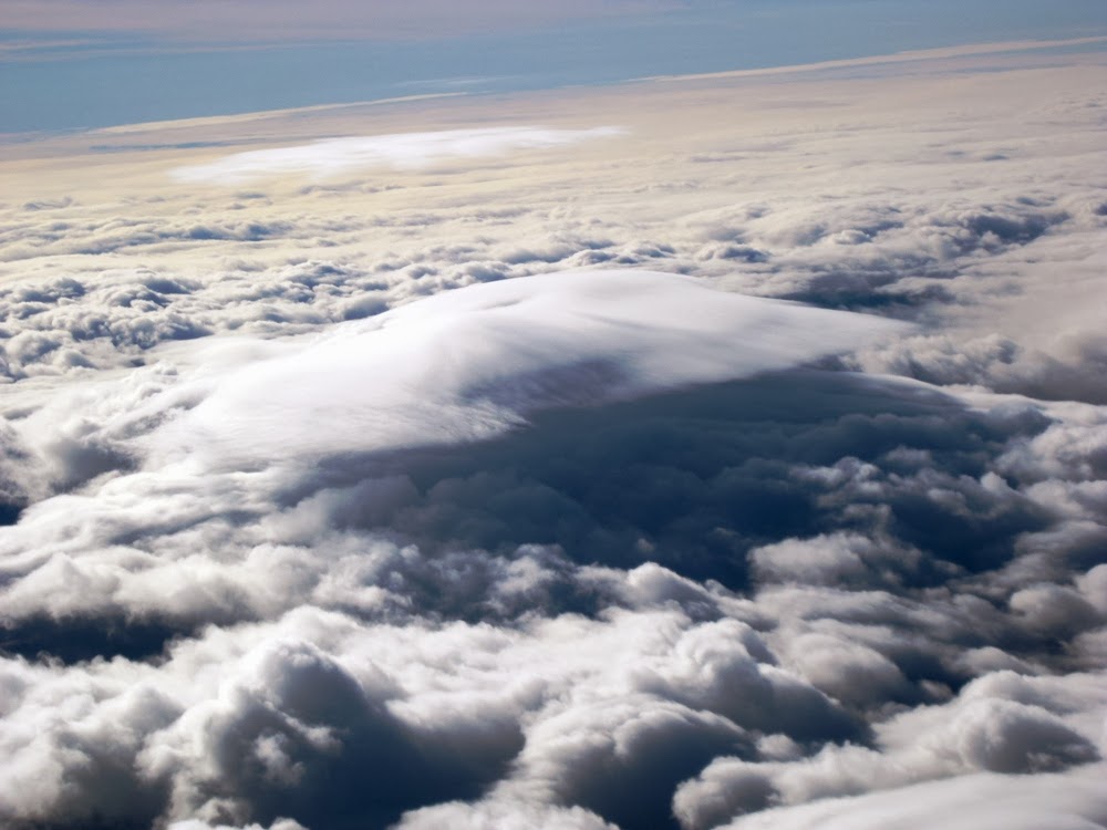
Here it was a solid 6 knots as I began climbing and working to the north.


This is looking out the left side of the glider. Snow Mountain is in the center of the photo and the southeast flank of Saint John's Mountain is in the lower right of the photo. The edge of the line of clouds marks the beginning of the Foehn Gap. (Looking into the wind)


This is looking straight ahead in the direction of orientation, not the direction of travel! Black Butte is somewhere in the distance under the clouds. (Direction of travel is L to R)


And this is looking out the right side of the glider. There would be no nice lenticular clouds to mark the upwind edge of the lift on this day. And the lower level scud clouds in the rotor areas were not even formed into nice wave bars. (Looking downwind)


I continued north until the lift just started to drop off. I decided to stop and retrace my path through the area of solid lift in order to gas up before exploring farther north.


As I returned to the north, I knew from the 13:00 10,000' (700mb) forecast map to expect a "bend in the road" at the location of the red arrow I added to the map.


The hard part is finding where that bend in the lift is while you're flying and you are not intimately familiar with the landscape in relation to the ClearNav map. So I took at stab at where I though it should be and started to alter my course to the left.

You can see in this photo that I was leaving the lift (green trace) and entering sink (black trace).


With the benefit of post-flight analysis, I think I may have not been too far off the mark. As you can see in the photo above, I was just over 17,000' and in zero lift. Well, the areas of lift at 10,000' are not the same as the areas of lift at 17,000'.

This map depicts the forecasted wave lift at 18,000' (500mb) at 13:00. I put a red arrow at the same "bend in the road" and you can see an area of decreased lift there. I think I may have been in that area. (See Update at the end of this post.)


Regardless, the views at 17,000' are always awesome! So I took a few photos before turning around to head south.

This is looking out the left side of the glider. (Wind is R to L)


And this is looking out the right side of the glider. (Wind is R to L)


I made my turn near Alder Springs and then began my first run to the south. My intent was to stay in the lift until it started to drop off and then return north. Based on the maps above, I expected this to occur in the vicinity of Goat Mountain's latitude.

I took these photos just after beginning the southbound run. (Wind is R to L)


As I made my way to the south, I tried very hard to maintain a proper airspeed and crab angle to stay in my desired cruising altitude band of 17,000' to 17,500' while also maintaining my desired flight track. This was something that I had learned from my flights with Kempton. I succeeded, but not nearly as smoothly as Kempton had demonstrated. I still need more practice with that.

I went a little farther south than Goat Mountain and then turned to return to the north. The going was pretty smooth as I just had to retrace my southbound track, and again be mindful to adjust my speed and crab angle accordingly.

But then I made a huge mistake! When I got back to same northernmost area that I had been at before, I once again started to experience sink. I was thinking that maybe I was too far upwind. So even though I am well aware that you should normally make your beat reversing turns into the wind while wave flying, I decided to make a quick turn downwind to simultaneously move a little downwind and reverse my direction of travel. Well, the 6 knots of sink I was in rapidly became 10 knots! I increased my bank angle from 45 to 60 degrees and sped up. The sink kept getting worse and maxed out at 22 knots down! (I was not aware how bad it actually was during the flight. I only learned this from post-flight analysis on SeeYou.) In the approximately 3 minutes it took me to make the turn and get back into the lift I lost 2,500'!

Sometimes the signposts in soaring are subtle. Other times they will whack you over the head if you just look outside the cockpit for them! As I was breathing a sigh of relief after leaving the area of enormous sink and was again flying to the south in the lift, I looked out to the west and noticed an area of clear air over the valley between Black Butte and M6. I thought to myself "I bet that's a Foehn Gap at the bend in the road." My first thought was that I'd fly up there on my next northbound leg. But then I thought "Wait a minute! Nothing says I have to go all the way south and back north before attempting to go up there! I'll just hang a right turn now."

This is looking out the right side of the glider at the Foehn Gap at the "bend in the road". M6 is under the clouds at about the center of the photo. (Wind is L to R)


Looking out the left side of the glider at the upwind edge of the "bend in the road" Foehn Gap. (Wind is L to R)


I had finally found the bend in the road!

In this photo you can see an aircraft depicted on the ClearNav display to the north of me. It had been detected by the Flarm (a collision avoidance device) and the information was transferred to the ClearNav display. It was a 747 passing at 28,000' and moving very fast!


Here I had progressed almost the farthest I went before turning to head southbound again.


By the time I returned as far south as Goat Mountain, I had been continuously above 16,000' for about an hour and a half (if you don't count those few minutes of shear horror!). I was freezing cold and decided not to go back north. Instead, I decided to just continue to the south for awhile and see how far I could go before returning to Williams while keeping an extra safe margin of altitude in reserve. I wanted no more unpleasant surprises on this flight!

This is looking northwest at Clear Lake as I headed south in the vicinity of Gold Mines.


And this is looking south at Lake Berryessa in the distance from the same point.


This shot is looking east at the Capay Valley from Berryessa Towers. You can see by the shadows on the ground that it was getting late in the afternoon.


And  lastly, here is Lake Berryessa just before I turned to return to Williams.


I returned to Williams and was eager to get the glider secured and get into the hangar for the nice ham and turkey meal that awaited! As I was walking in, I looked to the east towards the Sutter Buttes and noticed how beautiful the sky was as the sun was setting.


Here is my flight trace in SeeYou.


I posted the flight to OLC (On-Line Contest). It can be seen here:
http://www.onlinecontest.org - Pat Alford 14-1-11

Total time of the flight was 3.8 hours and OLC scored the distance at 328.5 km.


Update
As the regular readers of the Williams Today Forum are aware, Jim Darke has been doing some pretty fancy things with maps recently. Jim was a professional cartographer in a former life and has been tinkering with overlaying the RASP Blipmaps onto topographic maps that depict the Williams turnpoints. I asked Jim if he would work his map magic and add my flight trace to the 10,000' and 18,000' 13:00 forecasts overlaid onto the map of Williams turnpoints. Here are the results.


You can see that indeed I was close to the "bend in the road" on my first turn from the north to the south and way out of the lift on my second turn to the south. Thanks Jim, I really appreciate your efforts!

Saturday, December 7, 2013

First Solo Cross Country Wave Flight

Though far less spectacular than the epic wave flights I recently shared with Kempton Izuno (Extreme Wave Flight in FNX, and Wave Flight to the Pacific Ocean), I experienced my first solo cross country wave flight on Monday, December 2!

After those two incredible flights, I was eager to put what I had learned into practice. So I started watching the forecast winds aloft charts, and on Thanksgiving eve it appeared to me that the winds might be favorable for a wave flight on Monday, December 2. By Friday night, the RASP BLIPMAPs (a regional soaring forecast) were supporting my theory so I reserved Williams Soaring Center's ASW-24 for the day.

I set a very modest goal (by Kempton standards) to get in the wave near Goat Mountain and run as far north as Alder Springs' latitude and yo-yo between the two points and see how many "laps" I could do. Well, the answer ended up being just one!

I took off at 11:30 and towed west towards the mountains fully expecting to encounter wave on the way out. But the only lift we encountered during the tow was right near the airport just after taking off! The tow pilot took me to an area between Goat Mountain and Snow Mountain. I got off tow and started searching for the wave. After searching for almost ten minutes and thinking I might have to return, I finally connected with weak lift near Goat Mountain at about 8,500'. After mapping the area I started my initial climb.

The day started off void of any tell-tale lenticular clouds to help find the lift. This photo is looking to the north as I neared the top of my initial climb. The eastern half of Snow Mountain is on the left and Saint John's Mountain is in the center of the photo. You can also see the cloud deck of the approaching storm in the distance. (Wind is L to R)


The ClearNav display shows my initial search efforts and the small area I was working (the green tracks are in lift and the black tracks are in sink). The straight green track above my current position was while I was still on tow and I released where the track makes a 90 degree turn to the right. The black line that extends from the glider to the lower right of the display depicts the path back to Williams.


I climbed to 14,800' and then departed to the north. I went to Snow Mountain and attempted to find lift in an area relative to where I had found the lift at Goat Mountain, to no avail. Then I noticed that a well defined lenticular cloud had formed to the northeast of Saint John's Mountain and headed for it.

I entered the lift at about 11,000' and by the time I had climbed back up to about 14,000' I started north to my goal of Alder Springs.

This is looking north. You can see that the cloud deck had advanced, bringing moisture into the area which allowed the formation of the lenticular cloud at my "gas station". (Wind is L to R)


This is looking back to the the area of my initial climb. You can see: 1-Goat Mountain, 2-Clear Lake, 3-Mount Konocti, and 4-the Pacific Ocean.


This is essentially the same picture taken later in the flight during my third climb in the same area. I like the starburst effect of the sun reflecting on the canopy!


The lift continued as far north as Sheet Iron Mountain and then became not so insignificant sink! I had got as high as 15,500' when I encountered the sink, so I continued north thinking I might reconnect with the wave. I stopped my northbound progress when I got down to 13,000' and returned to the last known area of lift. I hadn't quite made it as far north as Alder Springs.

When I turned back to return to the gas station, I could see that classic lenticulars had developed high in the valley to the south of me. I did not consider trying for them as they seemed far away and I had not yet achieved my northbound goal. (Wind is R to L)


The combination of a cap cloud and lenticular clouds that were forming at Hull Mountain were quite interesting. They grew, evolved, and merged into a giant blob of cloud that completely obscured Hull Mountain. In my mind I was referring to it as Cloud Mountain. These shots were taken on my return to the gas station and during my second climb. All are looking into the wind.


When I got back to the gas station, I decided that I would climb higher before attempting another northbound run. Here is my ClearNav display during the second climb. You can see that my first northbound track was all in black after passing Sheet Iron Mountain. You can also see the the winds in the lower left corner showing 302 degrees at 60 knots! At one point during this climb, the entire view on the ClearNav display flipped 180 degrees as though I had turned around, even though I had not! I quickly realized that this had happened because I was being blown backwards over the ground. I pushed the stick forward to speed up and the display instantaneously flipped back to the "proper" orientation.


I climbed to 17,000' before beginning my second attempt to get as far north as Alder Springs. I decided to try a path more upwind this time in the hope that I would find a solid line of lift all the way to Alder Springs.

As I began north, Cloud Mountain had taken on a sort of a wind-swept, marshmallowy, cream puffy appearance. It reminded my of something that you might see in an advertisement for an air conditioning company or an ice company!


The sink I encountered on my second northbound attempt was even stronger than on the first attempt. So I aborted it earlier so I could return to the gas station and climb back up to 17,000' quicker. I had decided that I would try one more attempt to reach my northern goal and that this third and final attempt would now be downwind of my original attempt.

As I climbed and began my final northbound attempt, a lenticular cloud formed above Cloud Mountain as though Cloud Mountain was itself a physical, solid mountain.


I finally had success! I had gone north as far as Alder Springs and a little farther. I still did not find a solid lift line north of Sheet Iron Mountain, but I did encounter less sink on my final attempt. I decided I would go back and climb back to 17,000' before returning to Goat Mountain to complete lap #1. I also knew I would not be attempting a second lap as it was getting late in the day and the upwind runs and subsequent climbs were so time consuming.

Here the ClearNav shows that I'm heading back to the gas station and you can see all three of my attempts. The winds were now 300 degrees at 64 knots. Just like on my first flight with Kempton, the farther north I was, the higher the wind speed was. The highest I saw during the day was 70 knots. It appears that I am flying straight to the gas station with the nose pointed directly at it. But in actuality, I was crabbing into the wind almost 90 degrees!


As I climbed back up to 17,000' something interesting was happening to Cloud Mountain. It was flattening out. As though someone had took a pin to a balloon, Cloud Mountain was settling down to join the relatively uniform surrounding cloud deck.


As I headed back to Goat Mountain, Cloud Mountain continued its collapse and appeared to have imploded upon itself.


I arrived back at the area of my initial climb near Goat Mountain at 15,000' for the completion of Lap #1!  But I still had time before I needed to return to Williams, so I decided to fly south out to High Valley. Once there I opted to continue to the east shore of Clear Lake, which is obscured by clouds in this photo.


As I approached Clear Lake, I noticed a lennie forming downwind of Mount Konocti. Since I still had plenty of altitude, I decided to fly over to it and check it out.


The Mount Konocti wave was clearly displaying 3 of the 4 elements that make up a textbook wave system. 1-a cap cloud on the wave generating obstruction, 2-a Foehn Gap, and 3-the downwind lenticular cloud formation. The only thing not visible is a rotor cloud, which would be directly below the lenticular formation. But don't be fooled into thinking that just because there isn't a visible rotor cloud that there isn't rotor! (Wind is R to L)


I flew out in front of the lenticular until I encountered the anticipated lift. I did not attempt to map the lift and climb there, as I was already plenty high to return to Williams. Instead, I just topped of my tank by flying into the wind until the lift started dropping off and then began my return to Williams.

I was still at 5,000' when I arrived back at Williams. So I just oriented the glider into the wind and relaxed for about 5 minutes, contemplating the flight, warming my hands, and organizing the cockpit before I descended to land.

Here is my GPS flight trace from SeeYou.


I posted the flight to OLC (On-Line Contest). It can be seen here:
http://www.onlinecontest.org - Pat Alford 13-12-2

Total time of the flight was 5 hours and OLC scored the distance at just under 200 km. I'm still trying to figure out the whole OLC thing. I'm not sure why I wasn't scored from the time I released until after my first climb east of Saint John's Mountain (second climb of the flight). Maybe I should read their rules!

As I stated at the beginning of this post, this was not an epic flight by any stretch of the imagination. But it did give me a great feeling of accomplishment in achieving a number of goals on my first attempt at a solo cross country wave flight. Those goals were to 1) correctly interpret the weather conditions in advance, 2) set a reasonable goal for the flight based on the forecast, 3) adapt the flight to the conditions, and 4) arrive safely back home.

It's easy for me to do post-flight analysis and see where I made mistakes, or where I could have done things better. But hopefully those will become lessons learned that I can build upon for future flights. I can't wait to try it again!

Thanks again, Kempton, for the mentoring flights!