Kempton started a thread on the Williams Today Forum on Sunday, October 17, entitled "Wave Alert: Nov 21-22 (Thu-Fri)". In his post he announced an approaching "backside slider low" that was forecast to arrive Thursday night and persist all day Friday. He explained that this is a type of cutoff low that produces strong ENE winds because of its location on the "backside" (east side) of the coastal mountains as it "slides" south. The forecasted wind strength for this particular event was up to 50 knots at 18,000'. Kempton speculated that if the forecast was correct, it might be possible to fly west from Williams to the Napa Valley, then fly south and cross the Delta near Suisun Bay or the Carquinez Straight, fly to Mount Diablo or other points in the San Francisco Bay Area, and then return to Williams.
I was out of town and not scheduled to return until Saturday, so I read the posts to the thread with nothing more than great interest since I would not be able to fly Friday. But then my plans changed and I returned home on Wednesday! I immediately contacted Kempton to see if he had already made arrangements to fly with someone else since his ASH-25 (FNX) was in the shop. As I suspected, he was already tentatively planning to fly with Pete Alexander in Pete's Arcus (98). But Pete had a schedule conflict that he was trying to resolve. So Kempton agreed to fly with me in Williams Soaring Center's Duo Discus X (MG) as a backup plan.
You may have guessed, since I am writing this post, that Pete couldn't make it. On Wednesday night, the forecast winds were not looking too good for wave at Mount Diablo. So Kempton postulated that instead of the earlier plan, a flight to the north and west following subsequent downwind ranges and arriving at the Pacific Ocean might be possible. Additionally, Ramy Yanetz would be flying his ASW-27 (TG) out of Byron and attempting to fly north. So we would keep our options open and not rule out the original plan.
The potential fly in the ointment was that the surface winds at Williams were predicted to be from the north at 20-25 knots and gusting to 40 knots. Winds that strong could prevent us from even taking off! We arrived at Williams Friday morning and the winds were as predicted. But thankfully, Rex and Noelle agreed to tow us anyway. Noelle performed the tow and took us to the wave on the west side of Goat Mountain. We released at about 8,100'.
We contacted Ramy while we were still on tow. He had already climbed in the Mount Diablo wave and crossed the Delta to the Napa Valley and was heading north. Having an actual data point from Ramy tipped the scales in favor of the original plan to fly to Mount Diablo and return.
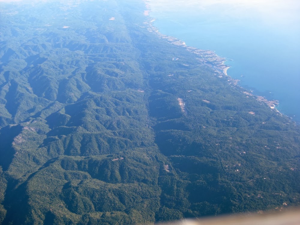
Here we are on our initial climb behind Goat Mountain at about 11,000'. Goat Mountain is to the left and not in the photo. The shot is looking to the south. The southeast portion of Clear Lake can be seen at the right in the photo. Kempton noted that the lift was farther downwind than normal, but this was not unexpected since the winds were so strong. (Wind is L to R)

Once we got above 17,000' we started heading southwest to Mount Saint Helena and the Napa Valley. The north and west shores of Clear Lake, Mount Konocti, Mount Saint Helena, and a large fire can be seen in this photo.

Several times during this flight we noticed very short-lived rotor clouds at high altitudes, like this one near the fire.

The fire became named the McCabe fire. It started that morning near a series of geothermal power plants in Sonoma County. As I write this (Monday night, November 25) the fire is 75% contained and has grown to 3,500 acres.
We contacted Noelle to find out if a TFR had been established near the fire. She informed us that none had and that she would monitor the situation and let us know if one was established.


As expected, we found great lift near Mount Saint Helena and climbed back up to our cruising altitude of 17,000' as we headed south in the Napa Valley. The views of the Pacific Ocean to the west of us were magnificent! Point Reyes can be seen in this photo. It is the promontory that the sun rays from the reflection of the sun on the canopy appear to be shining down upon.

And here is the San Francisco Bay, San Pablo Bay, and the Carquinez Straight. The Marin Headlands, the Golden Gate Bridge, and the city of San Francisco are also visible in the distance.

We struggled to find good, solid lift at the south end of the Napa Valley in order to climb high enough to make the crossing. We finally decided not to cross and instead return to the north. Ramy had reported that he had made it up to Ukiah in solid lift, so we set that as our new goal before returning to Williams.
I took several photos out the vent window as we turned back to the north. Suisun Bay, Grizzly Bay, and Mount Diablo can be seen in this photo.

Another shot of the San Francisco Bay Area.

I zoomed in for this photo to capture the Golden Gate Bride and the Richmond-San Rafael Bridge.

Here is the city of Napa.

As we continued north in the Napa Valley, we could see that the smoke from the McCabe fire was now clearly showing the contour of the wave as it streamed toward the ocean.


We found really strong lift as we approached Ukiah and had to fly fast and upwind out of the lift in order to avoid going above 18,000'. With a known good source of lift marked, we decided to try flying west towards the ocean and see if we could connect with the next wave crest. Success! We found the next wave near Boonville and climbed again. We could now fly farther downwind while keeping the two previous sources of lift within glide.
This shot is looking northwest as we left Boonville. Point Arena is on the left and we were heading for the coastline just south of it.

This is looking south as we approached the coastline. The San Andreas Fault is clearly evident.
The smoke from the McCabe fire extended out into the Pacific Ocean as far as our eyes could see.

Here is Point Arena as we neared the coast.

We stopped and circled once in good lift to gain a little more altitude before making the crossing.

Looking out at the Pacific Ocean.

Looking down at the coast.

And looking north as we went out over the ocean.

You can see in this photo that the ClearNav display is showing our position across the coastline. We were officially out over the Pacific Ocean! Now all we had to do was get back to Williams, a mere 85 miles away. Sounds easy enough until you turn into the 45 knot headwind and it appears that you have become stationary!

Kempton took this short video as we turned around.
I took a few more shots from over the ocean as we began our return journey. This is looking north up the coast.

This is zoomed in on Point Arena.

And this is looking south.

This jet was climbing out of SFO. We saw quite a few jets on this flight as the Napa Valley is a major corridor for SFO arrivals and departures. A Mode C transponder is a must for flying in this area!

We retraced our path out to the ocean back to Boonville and the wave was still working at all of the previous locations. But the going was slow as we progressed against the strong headwind. We used the terrain contours on the ClearNav to predict where the lift would be based on our earlier experiences in order to find a more expeditious path back home. We worked our way to 41 nm away from Williams and allowed our altitude to climb to 17,900' for the final glide home.
While we were making good progress and it appeared that we would make it back, we were now racing against the impending darkness. When we were still 25 miles out from Williams, we assessed our situation. We were just below glide to Williams, but in slight lift. In addition, we expected that the winds would decrease as we got lower and that we would get back to a solid positive glide. The problem was that we were only achieving a groundspeed of about 30 mph and it would take us almost another hour to get back. It would be completely dark by then. So we made the decision to return to Lampson Field near Clear Lake and await a ground retrieve.
Here we are at the decision point.

We flew back to Lampson Field at 120 knots. With a 45 knot tailwind we were traveling at close to 200 mph over the ground! We were on the ground in a little over 5 minutes.
Here we are crossing Clear Lake on our way back to Lampson Field.

Kempton took this photo just after we landed as I was preparing to get out so we could push off the runway.

Here is our GPS flight trace from SeeYou.

What an incredible experience this was! Thanks to Williams Soaring Center for making this flight possible, and especially to Nick and Danny for retrieving us! Kempton and I definitely owe you a nice dinner soon!