Kempton is a renowned glider pilot known for his long cross country flights. His accomplishments include having twice flown from Williams to Crater Lake and back! Kempton is also an extraordinary weather forecaster. So much so that SoaringNV enlists his services to forecast wave conditions for them at Minden, NV!
Kempton and I had been trying for several months to get our schedules in sync to go on a long flight in his ASH-25. The contest letters on his ASH-25 are FNX (pronounced Phoenix, after the mythological bird that rises from the ashes - but that's another story).
The ASH-25 is a high performance open class glider. I had flown a different one (25H) at Williams with Kenny Price on a half dozen or so occasions. Several of those flights were the subjects of earlier posts on this blog. See First Flight in the ASH-25, Third Flight in the ASH-25, and In-Flight Shots of 25H From 98.
On Friday night Kempton inquired about my availability to fly together on Sunday. He was predicting that an extremely long cross country wave flight could be possible out of Williams. I eagerly accepted his invitation and agreed to meet him at Williams Sunday morning.
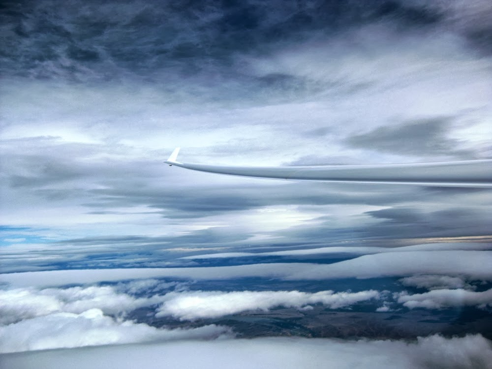
We took off at 09:30. (Note: All times are given in local military time and all altitude references are MSL.) We had just taken off and I was still getting situated in the cockpit when we contacted the first bit of lift. Kempton immediately released us at just 2,000'. He figured we were in the secondary wave and that we would gain some altitude and then push into the primary wave. Here we are at 8,700' just before heading west to search for the primary. (We later realized that we had actually released in the tertiary wave.) (10:04)

Ramy Yanetz, another accomplished glider pilot, took off just after us in his ASW-27 (TG). Here he is below us as we began to push west into the wind in search of the stronger lift we expected to find in the primary wave. (10:04)

The day started off with a high shelf of clouds void of the classic lenticular clouds, or lennies, that typically mark the presence of the wave. We expected to find the best lift just in front of the leading edge of the cloud shelf. (10:05)

We continued west until we contacted about 2 knots of lift and then began our first southbound leg. We had traveled about 20 miles south and had climbed to about 12,000' when we encountered slightly stronger lift. So we halted our southbound progression to climb higher. We pushed a little more west, flew north and south a little, and climbed to 16,000' before continuing the first southbound leg. (10:49)

We noticed that a distinct lenticular cloud had formed below the cloud shelf and ahead of us on our course, so we headed for the leading edge of it. (Wind is R to L) (11:01)

As we approached the leading edge of the lennie, another started to develop right in front of us. We had to alter our course to avoid flying through it. (11:04)

Before the flight, I had asked Kempton what my role in this flight would be. My primary role would be that of Chief Winds Reporter! I would periodically give him wind readings from the ClearNav display. I would also adjust the radio volume, report battery voltage, report our position relative to landmarks, take control of the glider periodically to free him to do other things, and of course I would also be ballast!
Here we have just made our first turnpoint near near the Lake Berryessa Dam and are proceeding on our first northbound leg. The winds were 258 degrees at 43 knots (lower left corner of the ClearNav display). (11:19)

Ramy was still beneath us at this point and nearly matching our flight path.(11:21)

This is looking back to the east (downwind) as we progressed north. The parallel rows of clouds are commonly referred to as wave bars and they form in the rotor area underneath the wave crests. They are aligned parallel to the upwind obstruction triggering the wave, the Mendocino Range in this case. You can tell from the right wing in the photo how much we have to crab into the wind to maintain our northerly track and not be blown downwind. Our flight path is actually parallel to the clouds! (11:44)

It was really easy to be drifted downwind on this day. Partly because of how strong the winds were, but more so because we were flying in relatively clear air in our immediate vicinity for a good portion of the flight. Therefore, we didn't have a nearby reference point to maintain our flight track against. Ground references are almost useless at the altitudes we were flying at because you could easily drift several miles before noticing any appreciable change in the picture below. And as the day progressed, the cloud cover beneath us was pretty much obscuring the ground anyway. We were really relying heavily on the ClearNav display to monitor how our flight track was progressing. FNX is only fitted with a ClearNav display in the front seat. Kempton has a Garmin GPS tracking display in the rear seat. But it doesn't display wind data or as many landmarks. This became an issue later in the flight.
More lenticulars started to form ahead of us to the north. In this series of photos we are maintaining our flight path to arrive in front of the clouds. Kempton pointed out that we needed to vary our crab angle depending on our airspeed in order to maintain a constant flight path. Notice in the first photo how our nose is almost pointed at the front of the lennies (faster airspeed) and notice in the third photo how our nose is pointed more into the wind (slower airspeed). (Wind is L to R) (12:02, 12:06, 12:15)


The ClearNav display is now warning us that we are approaching 18,000', the highest we can legally go without clearance from Air Traffic Control. In order to remain below 18,000' we had to fly progressively faster in areas where the lift was stronger (and remember to change our crab angle accordingly). The winds here are now showing 272 degrees at 47 knots. The farther north we progressed, the faster the winds became. They maxed out at about 65 knots and we sometimes had to fly as fast as 110 knots (Kempton established this as our Vne (never exceed speed) for our altitude) in order to maintain a constant altitude and flight path. (12:21)

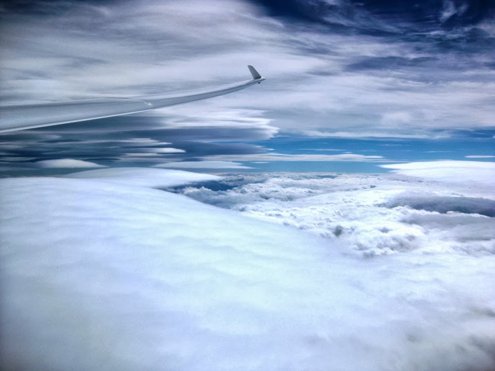
The view outside the cockpit was in a constant state of flux as the day progressed. Lennies would form, change size, shape and color, and disappear right before us. The constantly evolving sky was a feast for the eyes. This series of photos depicts my favorite views of the day. In my opinion, an artist couldn't have painted more awesome pictures! (12:27, 12:33, 12:43, 12:45, 12:45, 12:46, 12:48, 13:00)


The last photo above was taken just about the time we made our second turnpoint, just east of Eagle Peak. At some point during our ensuing southbound leg my ClearNav display suddenly went blank. Kempton asked me to reach around the back of the display and try to make sure that the connections were firm. They were. Damn! In an instant I had been battlefield demoted from Chief Winds Reporter to Chief Ballast Provider!
Subsequent troubleshooting isolated the problem to a short in the connector at the remote control. If I wiggled it just right and power cycled the ClearNav it would sometimes power back up, but more often not. And if it did power up and the cord was moved at all, it would power back down. So we were pretty much without wind data the rest of the flight. I say "pretty much" because we were getting reports from other pilots of the winds they were experiencing. Besides Ramy, Buzz Graves (BG), and Luke Ashcraft (SD) were also flying long distance flights in the wave. In addition, Kempton's Garmin displays ground speed data. So we could roughly calculate the wind speed from our ground speed versus our airspeed.
Here we are at our third turnpoint, near Guinda. You can see that the clouds below us and to the east have almost completely filled in at this point. (13:50)

The next northbound leg started off a little rough. We were having a tough time relocating the sweet spot in the wave. We ended up losing about 5,000' of altitude as we progressed north before getting back into the good lift northeast of St. Johns Mountain. But once we did, it was like getting on the freeway. Kempton realized that our track was now back on top of our previous southbound track, which we had said we would try to do when we passed through an hour and a half earlier.
As we approached the north for the final time, the lennies were getting fatter, with less defined edges. They kind of reminded me of the heated globs of wax inside of a lava lamp! (14:44, 14:54, 14:55)


The next photo is about as far north as we progressed. The lennies in front of us were creating canyon like formations. We were monitoring the cloud situation to the east of us closely in case we had to dive out into the valley. We knew we were getting close to our goal of T-16, but without the ClearNav display we couldn't know for sure where it was. We had our maps out but there was so much moisture in the air that the whole sky beneath us was covered in clouds which prevented us from getting any visual reference to our location. We heard Ramy report that he had turned T-16 and a few minutes later he passed underneath us as he headed southbound. Based on that information, Kempton said we would fly north for a few more minutes and then make our turn. He practically nailed it! (Wind is L to R) (15:19)

We were southbound here when we saw this stack of lenticulars. Kempton had me take control of the glider just after I took this photo so he could take a short video of it. (Wind is R to L) (15:41)

Here is Kempton's video. Notice how much the lennies have grown together in the short time between my photo and his video (~20 seconds). If you watch closely, you can even see them growing!
In this photo, we witnessed the white streaks at the bottom of the lenticular forming. They first appeared at the leading edge and nearly instantaneously extended the entire length of the lenticular and then got brighter. It was like a special effect in a movie! (15:46)

Looking back to the north one more time. (15:49)

We progressed south to Williams uneventfully. But then we encountered 2-5 knots of sink. We still intended to fly down to Vacaville for our final turnpoint, so we needed to find some lift if we were going to make it. We altered our course east into the valley as Buzz was reporting that the secondary and tertiary waves were working quite well. Then we altered back to the west in the hopes of finding the "kind air" that Luke had reported on the way into the Capay Valley. Finally we worked our way to this lennie near Esparto. Notice how the lenticular cloud bends as it extends to the south. If you look at our flight trace you can see how our track followed this curvature. (Wind is R to L) (16:36)

The lift was mostly zero sink. But Kempton worked it with such finesse that we only lost 300 feet in the next 10 miles. We were achieving a 175:1 glide ratio! Some quick mental calculations confirmed that we should be OK as long as we could arrive at Vacaville at 11,000' or higher.
Here we are arriving at the Nut Tree airport in Vacaville. We were still at 12,600' so we progressed a little further south to the edge of the Travis AFB airspace before turning and heading back to Williams. (16:57)

As we returned to the north we were descending to the top of the clouds that had filled in beneath us. We needed to find a hole to descend through. (17:26)

We decided on a hole that we could see north of us near the Rumsy Gap. The plan was to descend through the hole and then run the Cortina ridge back north to the Highway 20 gap abeam of Williams and then head east for home. I took this video as we got onto the Cortina ridge. I apologize for the shakiness, but we were flying at 120 knots in turbulent air! (17:50)
As we approached Williams we could see evidence that the tertiary and subsequent waves were still working. (17:59)

We arrived at Williams and were preparing for a high speed pass down Runway 16 when we noticed shafts of sun rays emanating from the clouds above Three Sisters. It was the final spectacular sight that Mother Nature conjured up for us on this flight. (18:02)

Kempton and me. (18:21)

The FNX tied down at the end of a long day! (18:55)

What an incredible once in a lifetime flight! Total flight time was 8.6 hours and we covered 859 km (534 miles). This flight was the second longest flight in the world posted to the Online Contest (OLC) website for the day. Here's the OLC link.
And here's our flight trace.

The main lessons I learned, re-learned, or had emphasized from participating in this flight are:
1. Managing your flight path on wave days is difficult.
2. Judging distances on wave days is difficult.
3. Try to plan three lift sources ahead of your current position.
4. You must adapt to changing conditions (have a Plan B, and ideally a Plan C as well!).
5. You must be prepared to respond to in flight equipment malfunctions (again, have a Plan B).
6. Use all information available.
7. Fly an open class glider at all times!
In short, in order to achieve this type of flight you better bring your A-game. Fortunately for me, Kempton Izuno doesn't have a B-game!
A very special thanks to Kempton for sharing this wonderful experience with me! And thanks also to Williams Soaring Center for making the flight possible!
Great flight; great reporting. Wish I was there :). Instead, was doing an intro lesson in blue-sky wave from MEV. Only covered 100+Km in about an hour in a 2-32 staying below 14,000 msl (no O2), but "student" (and me too) was impressed with what can be done without a motor. He'd be blown away by your flight.
ReplyDelete