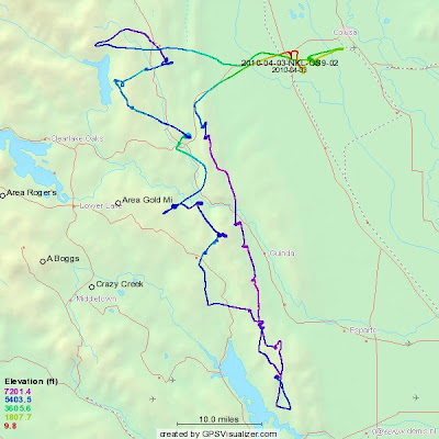
This turned out to be my second longest flight out of Williams, and it was the farthest South I had ever flown there. After towing out to the first mountain range, we flew South to Lake Berryessa, returned and made an attempt at Gold Mines, got low at the HWY 16/20 Intersection, got onto the Walker Ridge, made an attempt to Goat Mountain, returned to Williams, and then went most of the way to Colusa before returning to land.
What an incredible flight! No regrets that we weren't in the ASH-25, but I can only imagine that our "attempts" may have been more successful if we were!
What an incredible flight! No regrets that we weren't in the ASH-25, but I can only imagine that our "attempts" may have been more successful if we were!
Here, we are returning to the North after almost making it to the dam at the South end of Lake Berryessa.
The clouds show what and incredible post-frontal day it was!
Here's a good shot of Kenny working hard! I love the reflections of the wing and the tail surfaces on the canopy! Not to mention Kenny's furrowed brow!
This is our GPS trace from the flight.
Lake Berryessa is at the bottom of the map, Clear Lake is at the left edge of the map, and Indian Creak Reservoir is in the upper left quadrant.
We never got above 7,000 feet MSL, and it was cold that day! The Duo Discus' temperature gauge indicated that it was +3 C outside most of the flight. By the end of the flight my feet were frozen!
Flight time - 3.6 hours, Distance covered - 178 miles


No comments:
Post a Comment